Robot lawn mowers used to be easy to classify: perimeter wire or no perimeter wire.
That is no longer enough.
Modern wire-free robot mowers can navigate using:
- RTK/GNSS satellite positioning
- LiDAR
- cameras and computer vision
- inertial sensors
- wheel odometry
- or a combination of several systems
So the useful question is not:
Is RTK better than LiDAR?
It is:
Which navigation system is least likely to struggle with the conditions in your yard?
A wide-open half-acre lawn has very different navigation requirements from a shaded yard with mature trees, buildings, narrow side passages and several disconnected zones.
And increasingly, the strongest robot mowers do not rely on just one sensor.
Quick answer
If your yard is mostly open with a clear view of the sky, RTK can provide extremely precise and efficient navigation.
If your lawn has heavy tree cover, tall buildings or areas with poor satellite visibility, LiDAR or a strong hybrid navigation system deserves serious consideration.
If your yard contains many temporary obstacles—kids’ toys, garden furniture, animals or changing objects—camera-based vision can be particularly useful for understanding what is in front of the mower.
But in 2026, the most important trend is:
RTK, LiDAR and vision are increasingly being combined rather than used in isolation.
For example, ECOVACS currently sells an RTK mower that combines RTK with 3D-ToF LiDAR and AI vision, while its LiDAR models combine 360°/ToF LiDAR with cameras. Navimow’s current i2 LiDAR similarly combines LiDAR with vision rather than relying on laser sensing alone.
So when comparing mowers, look at the complete navigation stack, not just the largest acronym on the product page.
RTK vs LiDAR vs Vision at a glance
| Yard condition | RTK-first system | LiDAR-first system | Vision-first / vision-assisted |
|---|---|---|---|
| Large open lawn | Excellent | Very good | System dependent |
| Dense tree canopy | Can struggle without fallback | Strong potential | Good with capable system |
| Beside tall buildings | Can lose satellite quality | Strong potential | Often useful |
| Narrow side passages | Depends on sky visibility | Strong potential | Often useful |
| Precise virtual boundaries | Excellent in good satellite conditions | Very good | System dependent |
| Night mowing | Strong | Strong | Depends on camera/IR system |
| Dynamic obstacle recognition | Limited by RTK itself | Good when paired with obstacle sensors | Major strength |
| Very large open property | Strong use case | Product dependent | Product dependent |
| No external RTK antenna wanted | Network RTK may work | Usually yes | Usually yes |
| Complex shaded yard | Hybrid strongly preferred | Strong candidate | Hybrid strongly preferred |
This is not a product ranking.
Two mowers that both say RTK on the box can perform very differently because one may have sophisticated camera backup while another depends far more heavily on satellite reception.
First: what does RTK actually do?
RTK stands for Real-Time Kinematic positioning.
A robot mower receives satellite navigation signals and then uses correction data to calculate its position much more precisely than ordinary consumer GPS alone.
The correction data can come from:
- a local RTK reference station in your yard
- a network RTK service
- another manufacturer-specific correction infrastructure
Current Husqvarna iQ mowers, for example, use the company’s EPOS satellite-positioning system. In supported areas, Husqvarna can provide correction data through its cloud/network service; otherwise the mower can use a local reference station.
What RTK is particularly good at
RTK works very well for:
- large open lawns
- systematic mowing patterns
- accurate virtual boundaries
- repeatable positioning
- large zones with clear sky
- properties where perimeter wire installation would be inconvenient
This is why satellite navigation has become so important in modern wire-free robot mowers.
The main weakness of RTK: the mower still needs usable satellite reception
RTK correction improves positioning accuracy.
It does not make trees and buildings disappear.
The mower itself still needs sufficiently useful satellite signals.
Husqvarna’s current EPOS documentation says dense trees with wide crowns and tall buildings can block satellite coverage. Models without another backup system can therefore struggle in those areas.
This is exactly why we created our first troubleshooting cluster:
Robot Mower Losing RTK or GPS Signal? How to Find the Cause
Robot Mower Loses Signal Under Trees? What Actually Helps
How to Improve RTK Signal on a Robot Lawn Mower
Robot Mower RTK Base Station Placement Guide
If your mower already works well in open lawn but repeatedly loses positioning beneath trees, that pattern is much more informative than simply knowing the product supports RTK.
What is LiDAR?
LiDAR stands for Light Detection and Ranging.
A LiDAR sensor sends laser pulses into the surrounding environment and measures their return.
That allows the mower to build a spatial understanding of nearby:
- trees
- buildings
- fences
- lawn edges
- structures
- obstacles
- terrain features
The key distinction from satellite positioning is that LiDAR observes the mower’s local physical environment.
It does not need to see satellites to understand that a wall is three feet away.
Current ECOVACS GOAT LiDAR models, for example, use 360° and/or 3D-ToF LiDAR to build local 3D maps and navigate without an RTK reference station. ECOVACS specifically markets its current LiDAR navigation for complex, shaded and tree-covered areas.
Where LiDAR has an advantage
LiDAR becomes particularly interesting when the mower must operate:
- underneath tree canopy
- beside buildings
- in shaded areas
- through narrow passages
- where satellite visibility is inconsistent
- at night
ECOVACS says its current GOAT A3000 LiDAR creates a detailed 3D map using its LiDAR system and can navigate in complex layouts and at night.
Navimow’s current US i215 LiDAR similarly combines LiDAR and vision and is specifically positioned for navigation under trees and at night without an external antenna.
That makes LiDAR particularly relevant to the first commercial problem we identified for MowerCheck:
yards with substantial tree cover.
But LiDAR is not automatically better
It would be a mistake for us to turn MowerCheck into:
“Trees = buy LiDAR.”
A mower is an entire system.
LiDAR performance can depend on:
- sensor position
- effective sensing range
- mapping algorithms
- localization software
- how the mower recognizes lawn boundaries
- wheel odometry
- IMU data
- camera support
- environmental geometry
A large, flat and nearly featureless open lawn may actually be an easier environment for precise satellite positioning than for a mower that relies heavily on local environmental features.
And two LiDAR implementations can differ significantly.
So we should evaluate specific mower systems, not treat every LiDAR product as equivalent.
What does vision navigation mean?
“Vision” usually means one or more onboard cameras combined with software that interprets what the mower sees.
A camera can help identify:
- grass
- lawn edges
- pathways
- flower beds
- toys
- pets
- people
- garden furniture
- trees
- other obstacles
Some systems also use vision for localization or mapping through techniques such as visual SLAM or visual-inertial odometry.
Vision is particularly useful because it can answer a question that satellite positioning alone cannot:
What is this object in front of me?
RTK may know the mower’s coordinates.
A camera may recognize that a ball, animal or patio is in front of it.
Those are different capabilities.
Vision is increasingly being used as a backup for satellite navigation
This is one of the most important developments in modern robot mowers.
Current Husqvarna Automower models with AI vision use their onboard camera not only for obstacle recognition but also as backup navigation when satellite reception is temporarily weak.
Husqvarna says the mower can use its camera to verify that it is still on grass and continue mowing for a limited distance when EPOS satellite positioning is temporarily unavailable. If it cannot identify grass, it stops and waits for the satellite signal to return.
That is a good example of why the simple label:
RTK mower
doesn’t tell us enough anymore.
The more useful question is:
What does this RTK mower do when RTK becomes weak?
Night operation is where vision needs closer inspection
RTK satellite positioning does not depend on daylight.
LiDAR also measures laser reflections and can therefore operate without visible sunlight.
Camera systems vary.
Some vision systems are designed mainly for daylight.
Others use infrared illumination or other low-light hardware.
Husqvarna provides a useful real-world example: some of its current vision models use daytime vision only, while other models include infrared cameras that allow the vision features to operate day and night.
So never assume:
camera = works at night
or:
camera = doesn’t work at night.
Check the specific camera implementation.
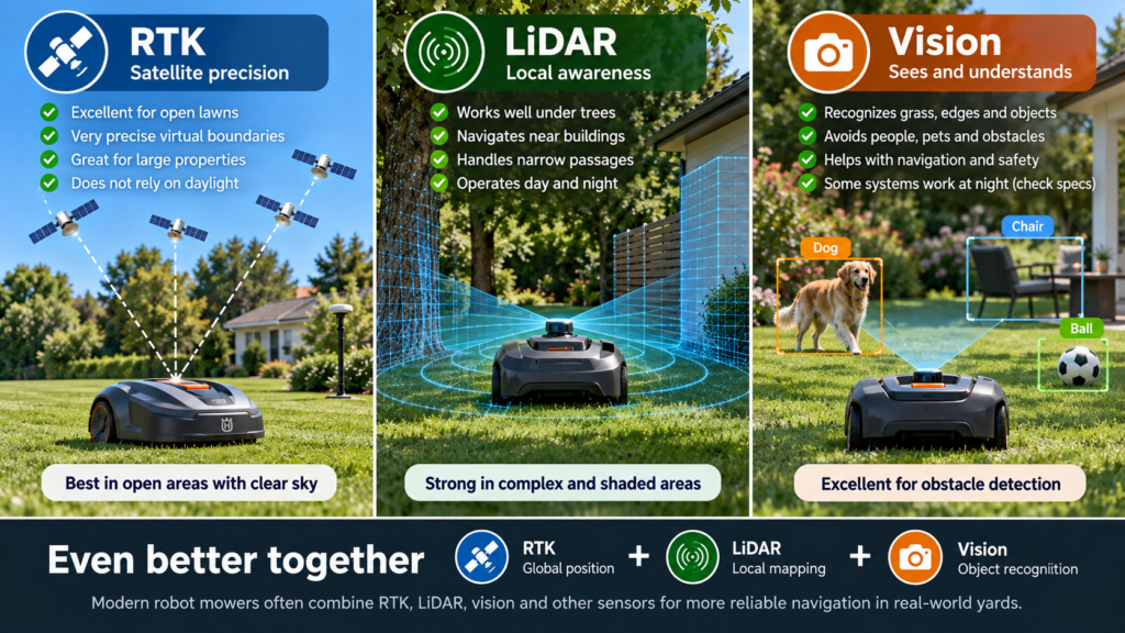
The real 2026 trend: hybrid navigation
This is where I think the market is going.
Instead of asking one sensor to solve every problem, manufacturers increasingly combine several.
A modern navigation stack might use:
RTK
for global position
+
LiDAR
for local geometry
+
cameras
for grass and obstacle recognition
+
IMU
for movement/orientation
+
wheel odometry
for short-distance position tracking
That makes much more sense than expecting one sensor to be perfect everywhere.
Example: RTK + LiDAR + vision
ECOVACS’ current GOAT A2500 RTK is a good example.
Its navigation specification combines:
RTK + camera + 3D ToF
and ECOVACS describes the system as LiDAR-enhanced RTK.
The mower uses satellite positioning while LiDAR and vision contribute to localization, edges and obstacle detection.
This illustrates why our eventual mower database should not contain a single field called:
navigation = RTK
Instead we should eventually track something closer to:
Primary positioning: RTK
Local sensing: 3D ToF LiDAR
Vision: Yes
Fallback behavior: verified separately
Reference station: required/optional/network
Night local navigation: verified
Tree-cover suitability: MowerCheck assessment
That’s far more useful.
Example: LiDAR + vision
Current ECOVACS GOAT LiDAR systems combine LiDAR with AI cameras.
The GOAT A3000 LiDAR, for example, uses a 360° LiDAR system plus 3D-ToF LiDAR and AI vision.
Current Navimow i2 LiDAR also combines LiDAR with a dual-camera vision system and does not require an external RTK antenna for navigation.
Again:
LiDAR mower
doesn’t mean:
LiDAR only.
Which is better for a wide-open lawn?
RTK has a strong case
If your lawn has:
- wide open sky
- limited mature tree cover
- few tall buildings
- clear mowing zones
- large open areas
RTK is particularly attractive.
Satellite positioning allows a mower to follow highly organized virtual routes without needing local physical boundary wires.
For large open properties, global position is a natural strength.
Husqvarna currently uses its EPOS satellite system across models from residential iQ machines to professional large-area mowers.
MowerCheck take
For a simple open lawn, I would not pay extra for LiDAR solely because LiDAR sounds newer.
A well-designed RTK system may be an excellent match.
Which is better under heavy tree cover?
This is where RTK-first systems become more dependent on their fallback technology.
If the mower spends substantial time beneath dense canopy, satellite reception can become inconsistent.
A local RTK reference station with perfect sky visibility does not automatically solve poor satellite visibility at the mower.
LiDAR is therefore especially interesting in wooded or heavily shaded yards because it can localize using surrounding physical structures rather than relying entirely on the sky.
Current US ECOVACS LiDAR mowers explicitly target shaded/tree-covered navigation, while Navimow’s US i2 LiDAR product specifically advertises operation under trees.
MowerCheck take
For heavy tree cover, I would investigate:
- LiDAR-first systems
- RTK systems with strong proven local fallback
- hybrid RTK + local sensing systems
before choosing an RTK-only approach.
This does not yet mean we recommend a specific product.
That comes later in:
Best Robot Lawn Mowers for Yards With Trees
after we verify individual models.
Which is better beside tall buildings?
Buildings can obstruct satellite sky visibility.
They can also create challenging narrow corridors such as:
house → side lawn → fence
For RTK, that may reduce positioning quality.
LiDAR and vision can potentially use the local environment to continue navigating.
MowerCheck take
If significant sections of your lawn sit:
- immediately beside tall walls
- between buildings
- underneath overhangs
- within narrow enclosed areas
then I would place greater value on local navigation capability than I would for a completely open property.
Which is better for narrow passages?
This is another case where mower dimensions and navigation technology both matter.
A mower may physically fit through a passage while still struggling to navigate it.
Imagine:
house on the left
tall hedge on the right
2.5-foot grassy corridor in the middle
RTK may have reduced satellite visibility there.
LiDAR can potentially use the corridor’s physical geometry.
Vision can help identify grass and edges.
A hybrid system may use all of these.
So when we eventually evaluate:
Best robot mower for narrow passages
we need to verify two things separately:
minimum physical passage width
and
navigation reliability inside that passage.
Those are not the same specification.
Which is better for obstacle-heavy yards?
Here, vision becomes especially valuable.
RTK primarily answers:
Where am I?
Vision can help answer:
What is in front of me?
Current Husqvarna AI vision systems classify and avoid objects while mowing.
ECOVACS similarly combines AI cameras and 3D-ToF LiDAR for obstacle recognition on current GOAT models.
Typical obstacle-heavy yards might contain:
- toys
- garden tools
- furniture
- fallen branches
- pets
- kids’ equipment
- temporary lawn objects
MowerCheck take
For these yards, don’t evaluate navigation position alone.
Obstacle perception deserves its own buying criterion.
Which is best for night mowing?
RTK
Strong in principle because satellite navigation does not depend on visible daylight.
LiDAR
Also strong in principle because laser ranging does not require sunlight.
Current ECOVACS and Navimow LiDAR systems explicitly promote nighttime navigation.
Vision
Depends strongly on the camera system.
A daylight-only camera may lose advanced vision functionality at night.
A system with infrared illumination may retain it.
Husqvarna’s current lineup contains examples of both.
MowerCheck take
If nighttime mowing matters to you, check:
Does the complete navigation and obstacle-detection stack function at night?
Don’t just read “AI camera” on the box.
Which is best for large properties?
For large, open yards, RTK remains very attractive.
Global satellite position scales naturally across open space.
For example, Husqvarna currently uses EPOS across residential machines up to its larger iQ/professional mower families.
LiDAR products also cover increasingly large lawns, but effective coverage is still a specific product capability, not something we should infer merely from the sensor.
MowerCheck take
For large properties, prioritize:
- verified mowable acreage
- mowing efficiency
- battery/charging behavior
- communication coverage
- terrain
- navigation reliability
before choosing solely by sensor technology.
What about a yard with trees AND slopes?
This is where buying based on navigation alone becomes dangerous.
A mower may navigate perfectly under trees but lack:
- traction
- all-wheel drive
- ground clearance
- slope capability
- suitable wheels
Conversely, a powerful AWD mower may climb steep slopes but struggle with the navigation environment.
So a wooded slope requires two separate evaluations:
Can it navigate there?
and:
Can it physically drive there?
Our eventual Yard Fit system should keep those dimensions separate.
What about disconnected lawn zones?
Suppose your front and back yards are separated by:
- driveway
- sidewalk
- gate
- narrow corridor
- gravel
- patio
The navigation technology is only part of the problem.
You also need to check:
- whether the mower supports multiple zones
- whether zones can be disconnected
- whether the mower can autonomously travel between them
- whether it must be manually carried
- whether a transport path is supported
Again:
RTK vs LiDAR tells us less than the full product implementation.
RTK reference station vs no antenna
A local RTK system usually requires installing a reference antenna.
That means considering:
- sky visibility
- mounting
- power
- communication range
- remapping if it moves
We cover that here:
Robot Mower RTK Base Station Placement Guide
Network RTK can remove the physical antenna requirement in supported areas.
Husqvarna, for example, currently offers EPOS through its cloud in selected US locations, while a local reference station remains available where cloud coverage is unavailable.
LiDAR systems can often avoid the external RTK antenna entirely.
Current Navimow i2 LiDAR and ECOVACS LiDAR systems are examples.
MowerCheck take
“No antenna” is a convenience advantage.
It is not by itself proof of better mowing performance.
What about perimeter wire?
Perimeter-wire mowers should not be dismissed simply because newer technologies sound more sophisticated.
A physical wire can still provide a predictable boundary in properties where:
- satellite visibility is poor
- local mapping is difficult
- the homeowner values mature, proven technology
- virtual boundaries offer little practical benefit
Husqvarna even uses a hybrid concept called EPOS Support by Wire on selected models, where a support wire can help the mower through areas with weak satellite coverage.
So the future is not necessarily:
wire bad → wireless good.
The real question remains:
What works reliably in this yard?
What I would choose by yard type
Mostly open suburban lawn
Prioritize:
RTK or strong hybrid RTK
Why:
excellent global positioning and virtual-boundary potential.
Lawn with several isolated trees
Prioritize:
RTK with proven fallback
or
LiDAR/hybrid
One or two trees do not automatically make RTK unsuitable.
Dense mature tree canopy
Prioritize:
LiDAR-first or strong hybrid local navigation
Satellite-only dependence becomes less attractive as the percentage of shaded lawn increases.
Narrow lawn between house and fence
Prioritize:
local sensing + verified narrow-passage capability
LiDAR/vision become particularly interesting.
Large open acreage
Prioritize:
RTK
but verify actual acreage capacity, charging efficiency and communication range.
Constantly changing obstacles
Prioritize:
strong vision/object recognition
preferably combined with robust positioning.
Complex yard with trees + buildings + several zones
Prioritize:
hybrid navigation
This is exactly the type of yard where I would avoid choosing a mower based on one sensor specification.
A better way to compare robot mowers
Instead of storing:
Navigation: RTK
MowerCheck should eventually evaluate:
| Navigation factor | Example |
|---|---|
| Global positioning | RTK / NRTK / GNSS |
| Local mapping | LiDAR / VSLAM |
| Vision | Single / stereo / multi-camera |
| Inertial sensing | IMU |
| Odometry | Wheels / visual-inertial |
| Satellite fallback | Vision / wire / LiDAR / unknown |
| Night capability | Full / limited / unknown |
| Obstacle recognition | Camera / ToF / LiDAR |
| External antenna | Required / optional / none |
| Internet dependency | Required / optional / none |
| Tree-cover resilience | MowerCheck assessment |
| Narrow-passage resilience | MowerCheck assessment |
This will become much more useful than manufacturer marketing labels.
Don’t choose by navigation alone
Even after finding the correct navigation architecture, a mower still needs to match:
- lawn size
- slopes
- cutting height
- grass type
- mowing width
- terrain
- ground clearance
- wheel traction
- zones
- charging access
- edge behavior
- service support
- replacement parts
- current US availability
This matters particularly in the US because grass requirements vary.
A navigation system that works perfectly in your yard doesn’t help if the mower’s cutting-height range is wrong for how you maintain your lawn.
Navigation is one major filter—not the entire buying decision.
Common comparison mistakes
“LiDAR always beats RTK”
No.
An open one-acre lawn may be an excellent RTK environment.
“RTK doesn’t work with trees”
Too simplistic.
Some yards with trees work perfectly well.
The amount, density and location of canopy matter, as does the mower’s fallback navigation.
“Vision means autonomous navigation”
Not necessarily.
A camera may be used only for obstacle avoidance while another technology provides primary positioning.
“All cameras stop working at night”
Incorrect.
Some systems include infrared/night-capable cameras; others do not.
“Network RTK fixes tree coverage”
Not automatically.
Network RTK removes the local correction station, but the mower can still need satellite reception.
Husqvarna explicitly notes that non-vision EPOS models still require good sky visibility across the lawn even when using cloud-based EPOS.
“Hybrid automatically means better”
Also not necessarily.
Adding sensors creates possibilities, but software integration determines whether they actually work well together.
We should verify the individual product rather than count sensors.
The MowerCheck decision test
Before choosing a navigation system, answer these six questions.
1. How much of your mowable lawn has open sky?
Almost all → RTK is very attractive.
Most → RTK + fallback deserves consideration.
Large areas covered by canopy/buildings → investigate LiDAR/hybrid systems.
2. Are there long narrow passages?
If yes, prioritize local navigation and verify actual passage performance.
3. Do you have many temporary obstacles?
If yes, prioritize strong object recognition.
4. Do you want to mow at night?
Verify the complete navigation and obstacle system works after dark.
5. Is installing an RTK antenna inconvenient or impossible?
Consider Network RTK where supported or antenna-free LiDAR/vision systems.
6. Is your yard simple or complex?
A simple open lawn usually needs less sensor redundancy.
A complex yard benefits more from a strong hybrid stack.
So which navigation system is best?
There isn’t one universal winner.
Choose RTK-first when:
your yard is relatively open, you value precise virtual boundaries, and satellite visibility is strong.
Investigate LiDAR-first when:
large parts of your yard are shaded, enclosed, close to buildings or otherwise difficult for satellites.
Prioritize vision when:
object recognition, edge understanding and backup navigation are important.
Strongly consider hybrid navigation when:
your yard combines several difficult conditions.
For MowerCheck, the most promising 2026 direction isn’t:
RTK vs LiDAR vs vision — choose one.
It’s:
Which combination gives this particular yard the fewest failure points?
FAQ
Is LiDAR better than RTK for robot lawn mowers?
Not universally.
LiDAR has an important advantage in locations where satellite visibility is poor because it can map the local environment without relying on GNSS in the same way.
RTK remains extremely effective in open lawns and can provide highly precise global positioning.
The yard determines which advantage matters more.
Does LiDAR work under trees?
LiDAR itself does not require satellite visibility, which makes it attractive under canopy.
Current ECOVACS and Navimow LiDAR systems specifically position their technology for operation in shaded or tree-covered conditions.
Actual mower performance still depends on the complete navigation implementation.
Does RTK work under trees?
It can, especially with partial canopy or a capable backup-navigation system.
But dense canopy can degrade satellite reception.
Husqvarna’s current EPOS guidance explicitly identifies dense trees with broad crowns as a possible satellite obstruction.
What is the difference between LiDAR and vision?
LiDAR measures distances to surrounding objects using laser light.
Vision systems interpret camera images.
LiDAR is strong at geometry and distance measurement, while vision can be especially useful for recognizing what an object or surface actually is.
Many modern mowers combine both.
Is RTK more accurate than LiDAR?
Manufacturers may publish very high positioning accuracy for both technologies, but comparing a single accuracy number can be misleading.
Real-world mowing also depends on calibration, mapping, local conditions, boundary logic and software.
Don’t choose solely from a claimed centimeter figure.
Do LiDAR robot mowers need an RTK antenna?
Not necessarily.
Current products such as Navimow’s i2 LiDAR and ECOVACS’ LiDAR GOAT models operate without an external RTK antenna for primary navigation.
Can vision replace RTK?
Sometimes vision contributes heavily to localization, but many current systems use it to supplement another positioning technology rather than completely replace it.
Husqvarna’s current AI vision implementation, for example, supplements EPOS satellite navigation when satellite reception becomes temporarily weak.
What navigation is best for a yard with lots of trees?
I would first investigate LiDAR-first systems and hybrid systems with proven local navigation.
But tree coverage is only one factor. Slopes, terrain, zones, cutting height and passages still need to be evaluated.
That’s why our next commercial guide will focus specifically on:
Best Robot Lawn Mowers for Yards With Trees
Final checklist
Before choosing between RTK, LiDAR and vision, ask:
- How much of the lawn has open sky?
- How dense is the tree canopy?
- Are tall buildings close to mowing areas?
- Are there narrow passages?
- Are there many changing obstacles?
- Will the mower operate at night?
- Do I want to install an RTK antenna?
- Is Network RTK available for the mower?
- What happens when its primary navigation fails?
- Does it use vision, LiDAR, wire or another fallback?
- Does the mower physically handle my slopes and terrain?
- Is the product currently supported and available in the US?
The most important takeaway is:
Don’t buy the sensor. Buy the navigation system that fits your yard.